Search
Arboviruses transmitted mainly by Aedes (Stegomyia) aegypti and Ae. albopictus, including dengue, chikungunya, and Zika viruses, and yellow fever virus in urban settings, pose an escalating global threat. Existing risk maps, often hampered by surveillance biases, may underestimate or misrepresent the true distribution of these diseases and do not incorporate epidemiological similarities despite shared vector species.
Quantifying the extent to which previous infections and vaccinations confer protection against future infection or disease outcomes is critical to managing the transmission and consequences of infectious diseases. We present a general statistical model for predicting the strength of protection conferred by different immunising exposures (numbers, types, and strains of both vaccines and infections), against multiple outcomes of interest, whilst accounting for immune waning.
With more than 1.2 million illnesses and 29,000 deaths in sub-Saharan Africa in 2017, typhoid fever continues to be a major public health problem. Effective control of the disease would benefit from an understanding of the subnational geospatial distribution of the disease incidence.

Children who live in the outer suburbs of Australia’s four biggest cities are twice as likely to have asthma as those living in inner city areas, according to a new study based on health data captured in the last Australian Census.
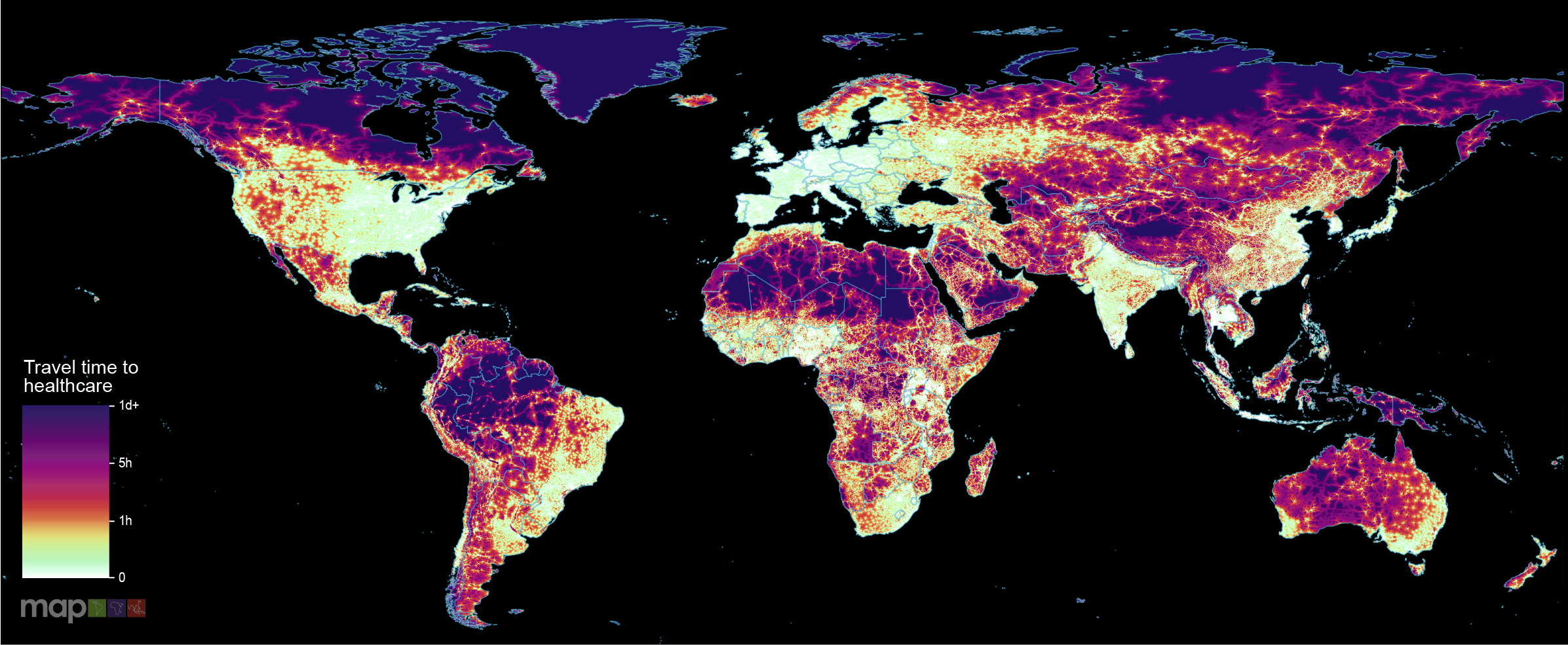
New research which maps the entire global population’s travel time to their nearest healthcare facility has revealed major inequalities in access to healthcare depending on whether people have access to motorised transport or not.
Since its inception in 2005, the US President's Malaria Initiative (PMI) has played a major role in the reductions in malaria morbidity and mortality observed across Africa. With the status of PMI funding and operations currently uncertain, we aimed to quantify the impact that a fully functioning PMI would have on malaria cases and deaths in Africa during 2025.
This study adds to the current literature by using a novel device-based method to explore where preschool children are physically active outside of home and childcare settings. This study combined accelerometry with geospatial data to explore the influence of the environment on preschool children's physical activity by objectively identifying the locations where preschool children engage in moderate to vigorous physical activity (MVPA) within and outside of their neighborhood.
Malaria imposes a significant global health burden and remains a major cause of child mortality in sub-Saharan Africa. In many countries, malaria transmission varies seasonally. The use of seasonally-deployed interventions is expanding, and the effectiveness of these control measures hinges on quantitative and geographically-specific characterisations of malaria seasonality.
Tuberculosis (TB) remains a major public health challenge in Ethiopia, despite being a preventable disease. TB preventive treatment (TPT) is a critical intervention to prevent the progression from latent TB infection to active disease, particularly among household contacts of TB patients and people living with HIV due to weakened immunity. However, the initiation and completion rates of TPT at subnational and local levels have not been thoroughly investigated. This study aims to map facility-based TPT initiation and completion rates among household contacts of TB across Ethiopia.
In the austral summer of 2021-2022, Australia experienced an unprecedented Japanese encephalitis virus (JEV) outbreak, with detections over 3000 km south of previous occurrences. Given the limited knowledge of JEV transmission ecology in Australia, we developed geospatial models of transmission risk to support the public health response. We created time-varying habitat suitability models for suspected mosquito vectors and ardeid hosts using month-scaled occurrence and covariate data from 2000-2023.